Forum Discussion
16 Replies
 TARDIS_TIME_TRAExplorerTARDIS" The Time Travel Adventures 2013
Of
Holly & Dave Fox
TARDIS (Time and Relative Dimension in Space) (from Dr Who)
This was our trip of a lifetime. We left home May 21, 2013, traveling south and west across the gulf coast, trying to stay out of tornado areas of the country. We headed north thru Texas, New Mexico, Colorado, Wyoming, Idaho, and Montana before crossing into Canada. We traveled from the 2013 Tiger Rally in Colorado with our friends in their Tiger from Colorado to Valdez Alaska. This part of our trip took us thru the Tetons NP, Yellowstone NP, Glacier NP throughout Alberta, British Columbia, and the southern tip of Alaska (Hyder), Canadian Rockies, Yukon, and on into northern Alaska at Tok. In Alaska we traveled down to Skagway, took a car ferry to Haines, back up to Tok & back down to Valdez Alaska. From Valdez on we went separate way thru the rest of Alaska and back home. Our travels continued around Valdez, the highlight being a mother grizzly bear and 4 cubs, over to Anchorage and up to Fairbanks. We camped at a friend’s home in Fairbanks and traveled from there on up to the Arctic Circle, back down to Fairbanks, on to Tok, and back into Canada. We went across the Yukon, up into the Northwest Territories, and then headed south thru the Yukon, British Columbia, Alberta and back into the US, arriving on August 7, 2013. We entered the US thru Montana and headed for West Glacier NP to meet up with friends from North Carolina. We took the “Road to the Sun” with them to Logan Pass, had a nice visit and then headed on our way to Belt Montana to visit with Holly’s friend Boots. From there we traveled thru North Dakota Badlands, South Dakota Mount Rushmore and the Badlands, and of course we stopped at Wall Drugs. While in the South Dakota Badlands we met a couple from Australia, who were RVing for 6 months in the US. They later camped at our home during their travels. Next we headed into Nebraska to visit Carhenge the US version of the British Stone henge. After all this we started heading east, towards home. We stayed with family in Grottoes Va. for 3 days of R&R before taking the last run of our journey. Our two dogs Nicky & Sandy did really well for the entire trip. On August 25 2013, we arrived home. We spent 97 days on the road in the Tardis our time travel machine, a 21 foot 2011 Ford F350 4X4 Bengal Tiger Class “C” RV built in West Columbia SC by Tiger Adventure Vehicles, Provan Industeies,LLC. It is bigger on the inside.
Our travels covered 15,000 miles of the most spectacular scenery in North America and the world.
The photos tell the rest of the story (20,000 photos) The important thing is there is something new and wonderful around every corner. Enjoy the trip
What’s next? Who knows?
We are looking forward to many more great travels adventures in the future.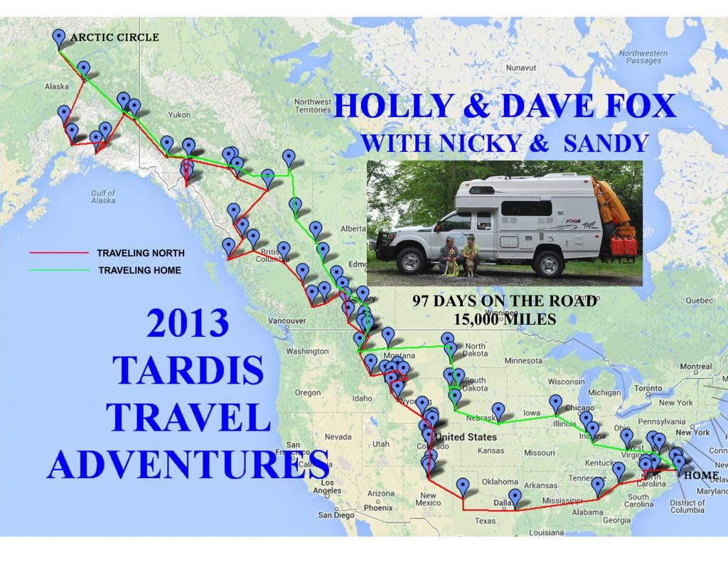
Our travel route (red going ~ green returning home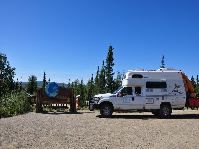
our most northerly location (The Arctic Circle)- crabbin_cabinExplorer IIIMHO! The best route is US 2 to east Glacier N.P. Take a couple of days there. Then 89 and 17 north to Waterton N.P in Alberta. N. to Pincher Creek and 2 miles west to highway 22 and north to Longview. #40 west and north thru the Kanaskis country to the TransCanada highway (#1). west thru Banff N.P to lake Louise then north on the Ice Fields Parkway (#93) to Jasper. East to Hinton then north on #40 to Grand Prairie and west to Dawson Creek and mile 0 of the Alaska Highway and away you go - assuming you are not too dazed by all the scenery so far!
Again -IMHO - that's the only way to go!!  joe_b_Explorer IIWhile, like everyone else I try to get the best prices I can find on any trip. But that doesn't mean I RV to see how cheap I can make the trip. I try to maximize the pleasure we get from the trips, instead. If a person has never been through the upper tier of states in the US, that makes for a nice ride. If a person has been through there but not the southern provinces of Canada, I would go that way just to see new country. Even though fuel is more in Canada, I find that camping generally is less and mostly offsets the difference in fuel. Many small Canadian towns will have a very low cost campground available, it may be dry or may have some services. Some are run by the towns and others are run by some service organization, such as Rotary, Lions, Kiwanis, Possum Lodge, etc. There is a service organization CG just south of Dease Lake on the Cassiar, a dry camp one, but it is $10 a night, beautiful , safe, along side a small creek. It is a bargain to my thinking. I have stayed in others with full hookups for very little more.
Booze is also a bit more in Canada, depending on what you like to drink. Any of the imports that come from the other Commonwealth countries that Canada is affiliated with, can import into Canada for a very low duty. I know that some people drink a lot more than I do, but most of us are only in Canada for a couple of two or three weeks each direction. $20 worth of beer will do me each direction of travel and we are talking real beer, especially some of the micro brews available. Canadian beer is not your wimpy 3.2 beer I run across here in the Lower 48, but they have beer with taste and alcohol. LOL The Whitehorse Brewery is worth the trip, just to sample some of their wares.
Over the years not too many crossings we haven't used, the busiest being the Rainbow Bridge in Niagara Falls and Blaine Washington. The most laid back, probably Roosville, north of Whitefish Montana. Sometimes the less traveled, are not the fastest to clear customs, as the officers have all the time in the world to spend with you and me. Over the 51 years, I have been driving the Alaska Hwy, I have crossed more at Coutts-Sweetgrass than anywhere else, with RVs, cars, airplanes, etc. It is a nice crossing, well run and staffed.
With any of the crossings, just know what you have on board, in the way of booze, fresh foods, tobacco products, etc. Pull up to the window when it is your turn, take off your sunglasses and have passengers remove theirs, shut off the engine and wait till the window opens. Answer all questions honestly, but don't volunteer info. If they want to know something, they will ask. Try to only have the driver do the talking, unless a passenger is asked a question. Don't try to be humorous or to make small talk, unless they start it. Having a sense of humor, is not one of the requirements to be a border officer on either side of the line. Just remember, you are talking to a federal cop, one that has vast amounts of information about you and me, and has wide discretion about what they allow or not. I have always found them to be very professional, highly trained and dedicated to protecting the borders of their respective countries.
I plan my trips based upon what I want to see and do, if I was worried about costs, I probably wouldn't have taken the ferry trip twice, but what a great experience, for my wife and me. One trip we crossed into Canada at Niagara, ran on north in Ontario, to the town of Tobermory, caught the ferry crossing Lake Huron, my first time to see the great lakes (I never realized there was that much fresh water in the world) then we headed west to Calgary and on to Alaska. The Prairie Provinces, one of the leading food baskets of the world, has a beauty all of it's own. Not a route I would take every time, but so worth doing it at least once.
Don't believe that there is a "bad" route to choose between south Florida and Fairbanks. LOL- prairie_camperExplorer
sljohnson1938 wrote:
Just for the heck of it I computed two different routes, both starting at Grand Forks, ND. This is where I plan to drive up to and spent the nite at Wal-Mart.
"""""
Ok - talk me out of plan A.
Our lowest cost diesel today was $4.45 CDN a gallon and I think the price is dropping I hope! I think your route A is a good one, from portal to Regina, Regina to Saskatoon, then on to Dawson Creek. Try not to cross the border (any border) into Canada on Sunday evening to many Canadians coming home after the weekend in the USA = long lineups. However route B takes you thru Alberta where fuel prices are among the lowest in Canada. The bottom line how much does time and distance and fuel cost mean to you?? Safe travels.  sljohnson1938ExplorerJust for the heck of it I computed two different routes, both starting at Grand Forks, ND. This is where I plan to drive up to and spent the nite at Wal-Mart.
Now I know my mapping program might be different than yours, but I would guess they would be close. Now at this point I could go North into Canada via Winnipeg or West and cross into Canada at many different places.
Route A - Grand Forks, ND to Minot, ND, then North to Portal, ND, cross into Canada and over to Dawson Creek. BC.
a. miles - 1382
b. at 60 mph = 23 hours.
c. at 15 mpg = 92 gallons
d. at 4.50 USD per gallon - $415 USD.
Route B - Grand Forks, ND West thru Minot, ND. , then Montana to Shelby, MT then North up to Dawson Creek, BC - thru Calgary.
a. 1565 miles
b. at 60 mph 26 hrs
c. at 15 mpg = 104 gallons
d. at 4.00 USD per gallon = $417 USD.
Now I know that I could probably cut a few miles here or there on both routes, but just for fun.
So taking route B I would drive 183 miles more and 3 hours more a spend $2 more for fuel. I also know the fuel prices could be way off of what I used. Lord knows what they will be in 2014.
Which route is best?
For me I plan to take Route A.
Even if fuel is $5 per gallon that would make fuel cost $460 which means fuel would cost $43 more, but I drove 183 miles or 3 hours less.
Ok - talk me out of plan A.- prairie_camperExplorer
ac bill wrote:
lizzie wrote:
Last summer we did the opposite of wanderingdogs, entered Canada near Oroville, came back through Alberta. Gas prices are higher in Canada so most folks try not to cross until they get way out west.
I'll second that! Not only is fuel going to cost you more, but so will most everything else. Grocery's, beer/liquor, propane, etc. Heck you could always stay south of the border till you hit BC, then cross over and head north. You hit Mile 0 of the Alaska Hwy at Dawson Creek.
You would really enjoy the trip through BC, more so than Alberta, as it is so beautiful..(although I may be somewhat biased..lol)
This site has links to fuel and campgrounds along the Alaska Hwy, you might find handy.
http://www.tourismdawsoncreek.com/
I'll agree that fuel,liquor and dairy products are more expensive here. However for a short period last summer diesel was cheaper in Winnipeg than Grand Forks N.D. And I can still fill a 20 lb. propane tank for $12. Most groceries are the same price as across the border, only liquor will always be more expensive here!! Now bear in mind one USD at present is 1.06 Cdn so you are ahead there. Each to his own as they say, however some costs are over exaggerated! Merry Christmas - ac_bill1Explorer
lizzie wrote:
Last summer we did the opposite of wanderingdogs, entered Canada near Oroville, came back through Alberta. Gas prices are higher in Canada so most folks try not to cross until they get way out west.
I'll second that! Not only is fuel going to cost you more, but so will most everything else. Grocery's, beer/liquor, propane, etc. Heck you could always stay south of the border till you hit BC, then cross over and head north. You hit Mile 0 of the Alaska Hwy at Dawson Creek.
You would really enjoy the trip through BC, more so than Alberta, as it is so beautiful..(although I may be somewhat biased..lol)
This site has links to fuel and campgrounds along the Alaska Hwy, you might find handy.
http://www.tourismdawsoncreek.com/ - VeebyesExplorer IIIt is not like there are alot of choices of routes. From MD the last time for us it was Portal but we have done others coming & going. Portal was busy the last time but that could have been just the time of day or people in front of us requiring extra attention, slowing everyone down behind.
It can seem like going through a toll gate or can take what seems like forever. Lots of variables.  lizzieExplorerLast summer we did the opposite of wanderingdogs, entered Canada near Oroville, came back through Alberta. Gas prices are higher in Canada so most folks try not to cross until they get way out west. From Western NC we go to the northwest via St. Louis & Kansas City, and then either I-70, I-80, or I-90 depending on the weather. If we leave in the spring and want to swing by the Four Corners area, we go out I-40. We like to return to NC via I-80 as Nebraska is not as boring as Kansas in the late summer. lizzie
- sljohnson1938ExplorerWhere in NC do you live ? We are in Mt. Airy. Where to cross over ? When we went up in 2004 we were in Grand Forks, ND and was going to cross over at Winnipeg, but we were told that there was a long waiting line. So were crossed over at Portal, ND. Took maybe 5 minutes, then stayed the nite at city park in Weyburn, SK.
All depends on your planned route.
About Bucket List Trips
13,488 PostsLatest Activity: Jul 25, 2025