Forum Discussion
paulj
May 22, 2013Explorer II
I like to use Google Maps. With terrain mode on it shows the contour lines. I estimate grades by asking it for the distance between two contour lines. Zoomed in far enough I can see every corner. With streetview I can see the actual road.
This is an area of low mountains, with roads following river valleys where possible. OR207 has some switchbacks as it crosses these mountains on the way north to I84. Those at 20 mph curves but aren't a problem for 18 wheeleres or logging trucks. As far as I know, Oregon does not have state highways like the California ones with length restrictions.
I see on GM that 402 is labeled as 'Old West Scenic Bikeway'.
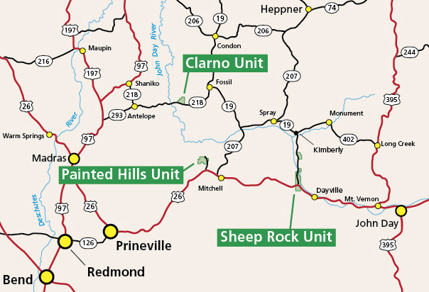
Check the John Day Nat Monument. It has several units in this area.
John Day NM map Clear map of the major (state) roads in the area.
Print maps with good topography detail are Benchmark and DeLourme Atlases.
This is an area of low mountains, with roads following river valleys where possible. OR207 has some switchbacks as it crosses these mountains on the way north to I84. Those at 20 mph curves but aren't a problem for 18 wheeleres or logging trucks. As far as I know, Oregon does not have state highways like the California ones with length restrictions.
I see on GM that 402 is labeled as 'Old West Scenic Bikeway'.
Check the John Day Nat Monument. It has several units in this area.
John Day NM map Clear map of the major (state) roads in the area.
Print maps with good topography detail are Benchmark and DeLourme Atlases.
About Bucket List Trips
13,488 PostsLatest Activity: Jan 17, 2025