Forum Discussion

tuna_fisher's avatar
tuna_fisher
Explorer
Dec 10, 2014

Lost Dutchman road?

Going to spend Xmas at Lost Dutchman Campground and have a question about the roads in the area. How far is it till the road turns to dirt? How far is Tortilla Flats? How much traffic is on that road and how fast do they travel? The reason I ask is we'll have 2 scooters with us and was wanting to ride, my wife isn't very experinced and trying to find if she will be ok on that road. Thanks.
If this is out of place feel free to move it.
  • tuna,
    Do you have google earth or google maps on your computer? It is pretty cool to get satellite photos and to be able to actually walk down that road via your computer. I use it to pick out my camp sites at campgrounds I haven't been to before. It really gives you the lay of the land.
  • RoyB's avatar
    RoyB
    Explorer II
    The Apache Trail is paved all the way to Tortilla Flats... After that it becomes a narrow dirt road with winding hills and curves... Not good for camper at all... Fish Creek canyon shows vehicles at the bottom of it that ran off the winding mtn trail above it...

    I always hated the water run off ruts on the dirt road... Would make my ole Jeep start dribbling and heading for the side everytime haha...

    Be sure to check out Tortilla Flats Restaurant/Bar. A 'got to see' adventure. haha...

    Check out Tortilla Flats AZ on GOOGLE SEARCH - When it loads up select 'IMAGES'

    The last time I was there coming back from the Roosevelt Dam and Canyon Lake we made it to the Fish Creek hill and a whole bunch of cars. Some dude tried to drive the Apache Trail with a big bus and got it hung up at the top of Fish Creek on some over-hang rocks. It was wait it out or drive a whole bunch of miles back up to Roosvelt Dam and come back a different route. We pulled off the road at Fish Creek and spent four to five hours watching the wrecker try to get the Bus pulled out from the over hang rocks... Bet they had a big wrecker bill... We was hoping they would just push it over the side...

    We had a good time waiting as there was a pretty good bunch of us stranded hanging out having fun...

    When the road finally opened back up then we all hit the Tortilla Flats Bar haha

    Only takes four to five Brewskis to fall off the real saddle stools they have there at the bar... Think I was sitting on Trigger that night...

    Roy Ken
  • Yes, check it out on Google maps. Lost Dutchman to Tortilla Flat is about 12 miles. After the first 2-3 miles, the curves start, so people cannot drive very fast. Can't remember what the speed limit is. Be sure to stop at the paved overlook parking area (overlooking Canyon Lake). There are also some dirt areas to pull off to the side if you feel the need to turn around, but hopefully you won't. It's a beautiful drive.
  • Thanks folks, yes I have looked at google maps, was just looking for current ist hand experince. Some of the maps are old. My wife is just learning to ride her scooter and isn't real secure in traffic. She can ride around Death Valley ok, but it's wide open.I mainly worry about *******s on the road!!!
  • RoyB wrote:
    The Apache Trail is paved all the way to Tortilla Flats... After that it becomes a narrow dirt road with winding hills and curves... Not good for camper at all... Fish Creek canyon shows vehicles at the bottom of it that ran off the winding mtn trail above it...

    I always hated the water run off ruts on the dirt road... Would make my ole Jeep start dribbling and heading for the side everytime haha...

    Be sure to check out Tortilla Flats Restaurant/Bar. A 'got to see' adventure. haha...

    Check out Tortilla Flats AZ on GOOGLE SEARCH - When it loads up select 'IMAGES'

    The last time I was there coming back from the Roosevelt Dam and Canyon Lake we made it to the Fish Creek hill and a whole bunch of cars. Some dude tried to drive the Apache Trail with a big bus and got it hung up at the top of Fish Creek on some over-hang rocks. It was wait it out or drive a whole bunch of miles back up to Roosvelt Dam and come back a different route. We pulled off the road at Fish Creek and spent four to five hours watching the wrecker try to get the Bus pulled out from the over hang rocks... Bet they had a big wrecker bill... We was hoping they would just push it over the side...

    We had a good time waiting as there was a pretty good bunch of us stranded hanging out having fun...

    When the road finally opened back up then we all hit the Tortilla Flats Bar haha

    Only takes four to five Brewskis to fall off the real saddle stools they have there at the bar... Think I was sitting on Trigger that night...

    Roy Ken


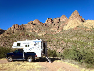
    Roy, I'm going to have to disagree about the Apache Trail not being good for truck campers. I've driven the trail a half dozen times, 3 with the truck camper, and had no problems. It does get tight going down Fish Creek Hill if you happen to encounter another vehicle going the opposite direction, but there's still plenty of room if you pass in the right spots.

    Here are a couple pics of us boondocking along Fish Creek (taken last month).


  • The Lost Dutchman State Park is very nice with some great trails to hike. As for travel beyond the pavement, you have about 22-23 miles from start to finish, it often is wash board like so plan on 2 hours or more minimum. Fish Creek Hill going from top to bottom is highly preferred as you will be on the inside next to the terrain not on the drop off side. It is not for the "faint of heart". The hill is mostly one lane with enough wide enough spots to pass. You'll usually see oncoming traffic far enough in advance to pull over and wait for them to approach and pass or vice versa. We've done it with the 1181. Just gear down so you don't have to ride the brakes for the 3 mile decent! I put into 4 wheel low and went at a fast walk pace. There is a nice campground 6 miles from the end of the gravel, so roughly 16-17 miles after starting gravel. The campground is called "Burnt Corral" and you can find it in the Tonto National Forest web page. Plenty of nice spots with many along the waters edge. No electric or dump out! You'll need to get a camp permit online or from a retail vendor as you cannot pay when you get to the camp. The scenery on this road is some of the best you'll find in Arizona. Early in the day while the light angles are still low will give you the best photos and viewing. There are also some boondock spots. Once you get to Roosevelt Dam and pavement, you'll have two choices on direction to travel either way is good. Kind of depends on what and where you want to see or do next and timeline. P.M. me if you'd like more details or respond here. The best advice on traveling beyond L.D. State park is, take your time, watch the road and don't worry about the A hole that comes up behind you, just let em go around when you get a wide spot. If you get the "single finger salute" or horn from some impatient moron, just think of it as a "howdy Welcome to Arizona" gesture!