Forum Discussion
 Gene_GinnyExplorer
Tvov wrote:
It looks like the jamming signal is being transmitted upward so anything on the ground will still be able to see the "birds". Anything in the air above the cone shaped area would have the satellite signal from above blocked by the jamming signal from below.
I'm curious how you can "block" GPS only in the air, but not on the ground? Wouldn't anything blocking it in the air, prevent the signal from getting to the ground? SCVJeffExplorerNow that the forum is back up again... I slipped a digit on the coordinates last night, it's actually in or around Ft. Irwin and there are lots of mtns out there. That's where Goldstone is also.
As far as the NOTAM, that doesn't mean it won't affect anything on the ground. Personally I'd like to know why, when the GPS quits working for no reason, even on the ground. Homer1ExplorerWhy are always looking for something worry about. I don't trust my GPS further than a block from home.
 ccxnolaExplorerFact Finder: Here is the NOTAM (Notice to AirMen)
https://www.faasafety.gov/files/notices/2016/Jun/CHLK_16-08_GPS_Flight_Advisory.pdf
Clicky
Now...I am no technical specialist, but the NOTAM is specific about the radius and altitude of the outage.
It is my understanding that the GPS reading comes from the co-ordination of two or more (three for a good reading) signals from satellites.
It is important to notice - the lowest altitude is 50 feet above ground level (AGL). It is somewhat strange that the 4000 ft notation is also "AGL" when in fact all aircraft use an altimiter (adjusted for local barometric pressure) and aircraft altitude is always noted as above mean sea level.
So...at the 50 foot level, it is an area from San Diego to Oakland and out in the desert past Lost Wages!!
It will be most interesting to see if the folks that travel in those mountains have any difficulties if they stay below 50 feet. harold1946Explorer
SCVJeff wrote:
Us out West wrote:
I would think both of you desert guys would have some idea how flat the desert is, and GPS at 1.5GHz is line of sight. This test is in East Edwards which, if a true jammer, will wipe out anything on the 58 and 395. So I think that qualifies.harold1946 wrote:
Are there that many RVrs that travel at 40,000 feet or even 50
Exactly....not an RV topic but whatever. :S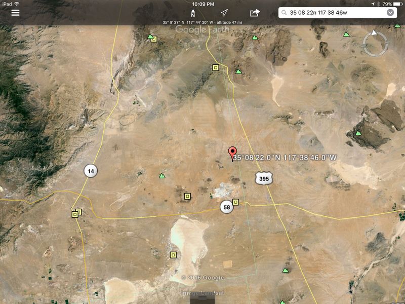
Anyone that needs a GPS within the test area radius on the 58 or 395 probably should not be driving. Even Ray Charles could have driven through that area and not gotten lost.
Has anyone ever gotten lost in the Isenhower tunnel when they lost GPS signal? :B JaxDadExplorer III
Tvov wrote:
I'm curious how you can "block" GPS only in the air, but not on the ground? Wouldn't anything blocking it in the air, prevent the signal from getting to the ground?
It's not just in the air, but because radio signals are easily blocked by things like trees or buildings it affects a far larger area in the air than it does on the ground.- nomad_297ExplorerFor years, whenever I get to within a few miles of Andrews AFB in Maryland and a few miles of the White House, my GPS starts to lose satellite connections. Some days are worse than others.
Bruce  TvovExplorer III'm curious how you can "block" GPS only in the air, but not on the ground? Wouldn't anything blocking it in the air, prevent the signal from getting to the ground?
- SCVJeffExplorer
Us out West wrote:
I would think both of you desert guys would have some idea how flat the desert is, and GPS at 1.5GHz is line of sight. This test is in East Edwards which, if a true jammer, will wipe out anything on the 58 and 395. So I think that qualifies.harold1946 wrote:
Are there that many RVrs that travel at 40,000 feet or even 50
Exactly....not an RV topic but whatever. :S - SCVJeffExplorerOh great !
So I got a brand bakers dozen box of missles and a couple of rusted VW's in the desert, and now you tell me I can't aim em' ?
About RV Must Haves
Have a product you cannot live without? Share it with the community!8,793 PostsLatest Activity: Aug 22, 2023