Forum Discussion

BC_Explorer's avatar
BC_Explorer
Explorer
Jun 20, 2017

Highway 20, BC - Closed

Highway 20, west of Williams Lake is closed until at least this weekend due to a major washout. There is a long and dusty detour in effect over some old logging roads. Certainly doable in an RV as long as you drive slow and share the road.

For those who are not familiar, Highway 20 goes from Williams Lake BC to Bella Coola on the central Pacific coast. Beautiful area and this washout could not have happened at a worst time with summer tourist season ramping up.

  • From google maps, I think the washout is a km up from the bridge:

    https://goo.gl/maps/RRwSEBnQ33n

    streeview is available. At this point the highway has climbed onto the first bench above the river.

    Culvert plus fill can fail completely if the culvert get's clogged, the water ponds and then finds its own way through the fill.


    Years ago, on the way back from Bella Coola I turned off of 20 before this grade (Riske Ck), and drove south to Gang Ranch and across the Churn Creek suspension bridge. That was long 90 mile gravel and dirt short cut. And this was a cute-ute, not a big RV.

    The Williams Lake Tribune has drone footage of the washout. The embankment just downstream from the road is still sloughing. I

    http://www.wltribune.com/
    http://www.wltribune.com/news/overnight-highway-20-washout-closes-highway-sends-one-to-hospital/

    It's interesting that there's little displacement or erosion among the trees and brush above road. The washout is entirely within the road fill and ravine sides downstream from there.

    Last year there was a washout and sinkhole on us101 in Brookings OR. It was caused by a damaged culvert. It affected 101, a parkinglot and frontage road.

    https://youtu.be/TR8FrGqx2kQ
  • paulj wrote:

    The Williams Lake Tribune has drone footage of the washout. The embankment just downstream from the road is still sloughing.

    That drone footage is from the same morning the washout occurred on.

    As the work progresses, it now looks completely different. Official word is the highway is still on track to be re-opened this weekend.

    Image is from about 4 hours ago.

  • The road opening has been pushed back to late next week. Change of travel plans for me...
  • When did the washout happen? It looks pretty dry now. How is a spring-time flood turned off so fast?
  • Latest repair video (see side bar for earlier ones)
    https://www.youtube.com/watch?v=f9Q0XH4fZyI

    Also more pictures on the Flicker photostream. The captions talk about putting in drains, so ground water accumulation was a big concern. In contrast to the washout on Hwy 1 near Revelstoke (good photos on Flickr), this was not caused by a flash flood or mud flow from further up the valley. The upstream edge of the fill was barely disturbed, and the culvert doesn't seem to have been exposed.
    closeup video before repair work
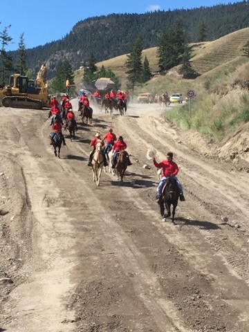
  • It's open to horse and wagon traffic!


    Chilcotin Riders Mount Up and Roll Out!

    Friday - open with gravel through the construction zone.