Forum Discussion
paulj
Mar 29, 2018Explorer II
An eastern Washington prof has a nice series of videos about Washington geology including several of the flood sites.
Nick on the Rocks - Dry Falls
and related links.
I'm sure there are guide books and other geological explanations. I've used a Roadside guide and field trip notes from Geological conferences.
Basically anything downstream from Missoula will show some evidence of these floods. That starts with MT200, ID200 past Sandpoint. Around Spokane the floods spread out. Much went down the Columbia River gorge, now Lake Roosevelt, and then flowed south around the current site of Grand Coulee Dam (there was an ice dam from another glace lobe further down stream).
WA155 follows this route SW from the Dam along Banks Lake. WA17 continues SW past the Dry Falls and Sun Lakes. Look at the area with Google Maps Terrain and Sat view modes to see the scouring.
Further west on US2 is Mosses Coulee, a dry canyon carved by the floods. WA172 north of US2 crosses moraines left by glaciers.
WA28 Wenatchee to Quincy gives you views of the downstream end of Mosses Coulee, and giant gavel bars deposited by the floods.
There's more evidence of erosion and deposition all along the Columbia to Portland. The flood waters formed lakes at constrictions like Wallula Gap (on the stateline) and backed up into side valleys at places like Portland. They also flowed overland between the Columbia and the Snake.
Palouse Falls off of WA261 (south from Washtucna, WA26) is a prime example of erosion as the flood waters drained into the Snake canyon. Again Terrain maps view is particularly revealing.
The irrigation system across central WA takes advantage of the flood geology. For example irrigation drain water collects in the Potholes on WA262. There isn't a lot of flood evidence on I90 except around the Columbia river crossing.
Most of SE Washington is covered with the Columbia basalts - thick layers of lava. Often that lava cooled in a columnar form that makes steep cliffs with plucked by flood waters. In other places they removed old soils, leaving bare rock out crops.
Major areas were covered by glacial loess, fine wind blown sediment. This forms rolling hills in SE Washington around Pullman, the Palouse. Scouring of these loess hills can be seen south of the Potholes.
http://www.sevenwondersofwashingtonstate.com/the-channeled-scablands.html
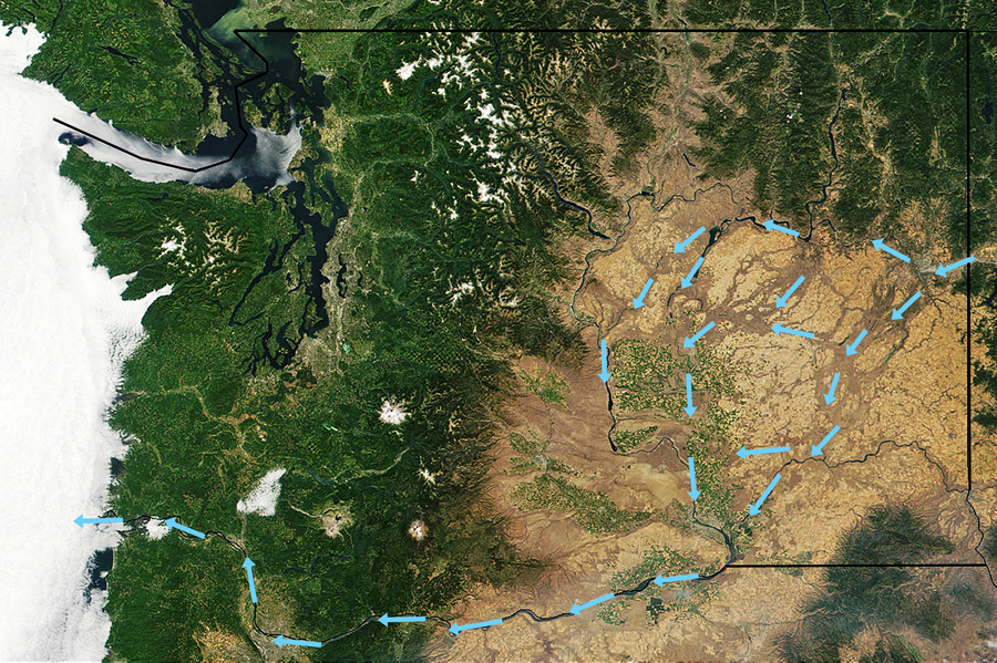
Just follow the arrows on this map. :)
Nick on the Rocks - Dry Falls
and related links.
I'm sure there are guide books and other geological explanations. I've used a Roadside guide and field trip notes from Geological conferences.
Basically anything downstream from Missoula will show some evidence of these floods. That starts with MT200, ID200 past Sandpoint. Around Spokane the floods spread out. Much went down the Columbia River gorge, now Lake Roosevelt, and then flowed south around the current site of Grand Coulee Dam (there was an ice dam from another glace lobe further down stream).
WA155 follows this route SW from the Dam along Banks Lake. WA17 continues SW past the Dry Falls and Sun Lakes. Look at the area with Google Maps Terrain and Sat view modes to see the scouring.
Further west on US2 is Mosses Coulee, a dry canyon carved by the floods. WA172 north of US2 crosses moraines left by glaciers.
WA28 Wenatchee to Quincy gives you views of the downstream end of Mosses Coulee, and giant gavel bars deposited by the floods.
There's more evidence of erosion and deposition all along the Columbia to Portland. The flood waters formed lakes at constrictions like Wallula Gap (on the stateline) and backed up into side valleys at places like Portland. They also flowed overland between the Columbia and the Snake.
Palouse Falls off of WA261 (south from Washtucna, WA26) is a prime example of erosion as the flood waters drained into the Snake canyon. Again Terrain maps view is particularly revealing.
The irrigation system across central WA takes advantage of the flood geology. For example irrigation drain water collects in the Potholes on WA262. There isn't a lot of flood evidence on I90 except around the Columbia river crossing.
Most of SE Washington is covered with the Columbia basalts - thick layers of lava. Often that lava cooled in a columnar form that makes steep cliffs with plucked by flood waters. In other places they removed old soils, leaving bare rock out crops.
Major areas were covered by glacial loess, fine wind blown sediment. This forms rolling hills in SE Washington around Pullman, the Palouse. Scouring of these loess hills can be seen south of the Potholes.
http://www.sevenwondersofwashingtonstate.com/the-channeled-scablands.html
Just follow the arrows on this map. :)
About Bucket List Trips
13,487 PostsLatest Activity: Jan 18, 2025