Forum Discussion
 FIRE_UPExplorer
Ray & June wrote:
The road starts in Mesquite as the south frontage road to I-15. The Scenic turnoff is about 3 miles down the road, but the frontage road continues on to Littlefield AZ, about another 8 miles down the road.
It is slow but worth the drive if you have the time.
When we're coming from the north we get off at Littlefield/Beaver Dam to see our friends.
It is paved the whole way.
I surely want to thank you for your explanation of its whereabouts. We must have been fairly close to its origin in Mesquite several times. You see, on our way to the Easter Jeep Safari in Moab UT, we (about 10 motor homes towing Jeeps) would pull off at the first Mesquite off ramp (heading N on I-15 from San Diego) and head up to the new ultra large Walmart for nights stay.
So, the entrance to that road must be fairly close by. I'll have to remember it as a little Jeep tour in our travels in the area. Thanks so much for your help here.
Scott Ray___JuneExplorerAfter looking at your photo again, I think it is the back road into Scenic. That road is gravel for about 6-7 miles from the middle of Mesquite, south and then east to the southern-most main road in Scenic.
We've driven it many times in our CRV at about 25-35 MPH without any problems.- Ray___JuneExplorerThe road starts in Mesquite as the south frontage road to I-15. The Scenic turnoff is about 3 miles down the road, but the frontage road continues on to Littlefield AZ, about another 8 miles down the road.
It is slow but worth the drive if you have the time.
When we're coming from the north we get off at Littlefield/Beaver Dam to see our friends.
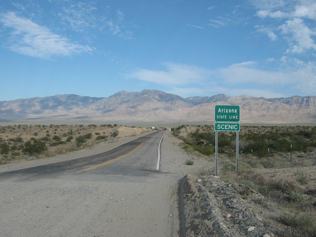
It is paved the whole way. - FIRE_UPExplorerHey that's cool. I appreciate the research and answer. I was wondering where that particular road is. It appears that, maybe, it's the beginning/end of a dirt road and, the beginning of the pavement, right at an Arizona boarder, with Mt Bangs maybe in the distance?
Scott - Ray___JuneExplorerScenic AZ is just east of Mesquite NV on the Arizona strip of I-15. We have 4 friends who live there, one who just closed on a house 6 weeks ago.
From their house to the Smiths grocery store in Mesquite is a little over 9 miles, but about a 15 minute drive.
It is becoming very popular, but too much desert for us. - gboppExplorer
2oldman wrote:
MNGeeks61 wrote:
Now that's pretty cool.
Not sure if all browsers have it, but Chrome = right click, google search image.
That's beyond cool.... - gboppExplorerI'm guessing it's somewhere along the AZ state line. :B
 2oldmanExplorer II
MNGeeks61 wrote:
Now that's pretty cool.
Not sure if all browsers have it, but Chrome = right click, google search image. MNGeeks61ExplorerFound it
Not sure if all browsers have it, but Chrome = right click, google search image.
I also used Tineye to find similar pictures.
Edit:
"Mount Bangs is located in extreme northwest Arizona, tucked into the corner of the state near Mesquite, Nevada, and St. George, Utah. It is the highest point in the section of the Virgin Mountains that extend into Arizona from Nevada (the highest point in the Virgin Range is Virgin Peak, in Nevada)."
About Motorhome Group
38,708 PostsLatest Activity: Mar 04, 2025