Forum Discussion

DHart's avatar
DHart
Explorer
Jul 01, 2013

Good route Portland, OR to Phoenix, NOT thru California?

If you have good suggestions for a route from Portland, OR to Phoenix, AZ which does not involve California, I would appreciate your input.

Someone told me that there was a new, very nice highway through part of Nevada, but I forget what that route is.

We recently made the route along Columbia River Gorge I84, then through SLC, Las Vegas, then Phoenix, but I'm thinking a route through Nevada would be more direct.

We don't need scenic, this time, just fairly direct and nice roads would be good.

Thank you!
  • First, do you want completely avoid California, or just the Central Valley routes (I5/CA99)?

    Alternative 1:
    - I5 to Shasta, then diagonal over to Reno, US95 to Vegas. That's been discussed a number of times

    Alternative 2:
    - US97 to Klamath Falls, diagonal over to US395 in northern Calif. US395 to Reno.

    Alternative 3:
    - US97 to La Pine, OR 33 (?) to Lakeview, US395 south

    Alternative 4:
    - to Bend, US20 to Burns, OR 78? to US95 south to Winnemucca (sp?), then then south to Vegas (don't have go through Reno)

    Alternative 5:
    - I84 to Ontario, US95 south

    Alternative 6:
    - I84 to Twin Falls, US93 south to Vegas. US93 has often been discussed as an alternative to I15 to Vegas.

    Focusing on the middle part. The NS options are US395 (some Nevada, mostly eastern Calif), US95, US93 (I15 if you really must have freeway). For the most part these highways follow NS valleys between mountain ranges. While there are some grades, there aren't any difficult passes or curves.
  • Earl... that's not a bad idea... I will definitely consider it.

    I'm actually even considering a re-do of our trip north last May... I-84 east up the Col. River gorge, down to Baker City, to Boise, Salt Lake City, Las Vegas, Phoenix.

    It's a couple of hundred miles longer this way, but my reasoning is that there are many more good places to stop for the night all along the way, with very little in the way of long, long desolate stretches.
  • Yarnell, AZ is just 85 miles outside of Phoenix and 19 firefighters are unaccounted for... 18 feared dead. News still coming in so I don't want to quote data. I want to alert you that you need to keep on top of the fire alerts.

    Weather Underground will plot a course... and if you click on
    the weather/traffic alerts ... will give you road and weather advisories.

    Still it's better to get "feet on the ground" information and you almost can't beat the members here for that.

    Weather Underground
  • I know you said "not CA" but if you are willing to do just a few hours in CA, it will be much faster going down I-5 to Eugene and cross over to 97, then drop down to Susanville or Alturas, and into Reno, Las Vegas and across to Phoenix. Good roads all the way.
  • That's it. Going through twin falls sucked. It seemed to take forever weaving through all the smaller roads.

    Also, lots of big head winds going through idaho.
  • Google came up with this, but I have no idea about road quality and such.


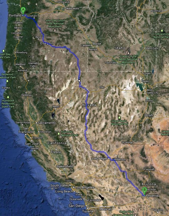
    13. Continue onto US-26 E
    103 mi
    14. Turn left onto US-26 E/SW Madras-Prineville Hwy
    26.1 mi
    15. Slight right onto OR-126 W
    2.6 mi
    16. Turn left onto Airport Way
    348 ft
    17. Continue onto SW Millican Rd
    18.0 mi
    18. Continue onto Low Desert Rd
    0.1 mi
    19. Continue onto 6520
    11.8 mi
    20. Turn left onto US-20 E/Central Oregon Hwy
    Continue to follow US-20 E
    102 mi
    21. Continue onto E Monroe St
    0.5 mi
    22. Continue onto OR-78 E/Crane Blvd/Steens Hwy
    Continue to follow OR-78 E/Steens Hwy
    90.7 mi
    23. Keep right to stay on OR-78 E/Steens Hwy
    0.4 mi
    24. Continue onto US-95 S/I O North Hwy
    Continue to follow US-95 S
    Entering Nevada
    129 mi
    25. Turn left onto W Winnemucca Blvd
    0.5 mi
    26. Continue onto E 2nd St
    322 ft
    27. Take the ramp onto I-80 E
    52.4 mi
    28. Take exit 231 for Nevada 305 toward Downtown/Battle Mountain
    0.3 mi
    29. Turn right onto NV-305 S/S Broad St
    Continue to follow NV-305 S
    87.0 mi
    30. Turn left onto Lincoln Hwy/US-50 E
    12.7 mi
    31. Turn right onto NV-376 S
    99.8 mi
    32. Slight right toward US-6 W
    0.1 mi
    33. Continue straight onto US-6 W
    5.3 mi
    34. Turn left onto US-95 S/Erie St
    Continue to follow US-95 S
    92.9 mi
    35. Turn left onto US-95 S/S 2nd St
    Continue to follow US-95 S
    40.4 mi
    36. Continue onto Veterans Memorial Hwy
    59.0 mi
    37. Continue onto US-95 S/Veterans Memorial Hwy
    17.0 mi
    38. Continue onto I-515 S/US-93 S/US-95 S/Great Basin Hwy
    22.6 mi
    39. Continue onto US-93 S/Great Basin Hwy
    3.2 mi
    40. Turn left to stay on US-93 S
    Entering Arizona
    77.1 mi
    41. Turn left to merge onto I-40 E/US-93 S toward US-93 S/Flagstaff/Phoenix
    22.4 mi
    42. Take exit 71 for US-93 S toward Wickenburg/Phoenix
    0.4 mi
    43. Slight right onto US-93 S
    106 mi
    44. At the traffic circle, continue straight onto US-93
    1.2 mi
    45. At the traffic circle, take the 2nd exit onto US-60 E/E Center/E Wickenburg Way
    Continue to follow US-60 E
    38.4 mi
    46. Turn right to merge onto AZ-101 Loop S
    9.3 mi
    47. Take exit 1B on the left to merge onto I-10 E toward Phoenix
  • okay, I'm link challenged...

    Our route went through twin falls idaho. The long stretch through nevada on 93 in the dark was very lonely (we drove straight through)
  • LoudDog... thanks... I do plan to Google Maps a route, but was also looking for recommendations as well, based on RVer's experience. Thank you.
  • google will give you the inside route, probably not a bad route in the summer. We did seattle to phoenix last christmas, took the inside route there and the CA route back. Weather was too iffy on the inside route on the way down.

    CA route was much faster, but that may have been mostly weather related.