Turn on suggestions
Auto-suggest helps you quickly narrow down your search results by suggesting possible matches as you type.
Showing results for
- Good Sam Community
- Groups
- Bucket List Trips
- Forum
- Re: Oregon between Westfir and McKenzie Bridge
Options
- Subscribe to RSS Feed
- Mark Topic as New
- Mark Topic as Read
- Float this Topic for Current User
- Bookmark
- Subscribe
- Mute
- Printer Friendly Page
Oregon between Westfir and McKenzie Bridge
Options
- Mark as New
- Bookmark
- Subscribe
- Mute
- Subscribe to RSS Feed
- Permalink
- Report Inappropriate Content
Jun-17-2013 08:33 PM
Okay all you rugged types! Need to hear if the road between Westfir and McKenzie Bridge (shows up as a "grey" on my maps) is passable with a 27ft fifth wheel. On the map it looks like it will save me having to go all the way to I5 and then back East again up the McKenzie. All information appreciated.
Jacques, Denise, and Wolf
2004 GMC Sierra Denali (AWD/6L/4:10/Quadrasteer)
2005 Crossroads Cruiser 27RL
2004 GMC Sierra Denali (AWD/6L/4:10/Quadrasteer)
2005 Crossroads Cruiser 27RL
Labels:
- Labels:
-
Roads and Routes
6 REPLIES 6
Options
- Mark as New
- Bookmark
- Subscribe
- Mute
- Subscribe to RSS Feed
- Permalink
- Report Inappropriate Content
Jun-18-2013 04:14 PM
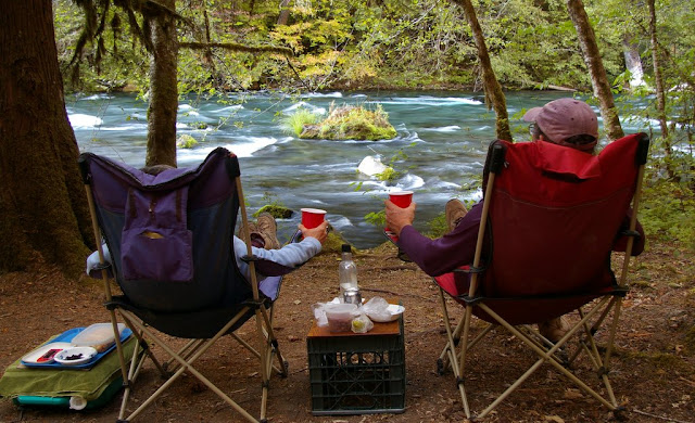
When you get to the McKenzie Bridge area, spend some time there -- great area. Paradise Campground was aptly named:

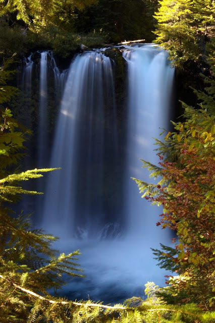
And there is a great mtn bike trail along the river -- it goes all the way to the falls:

And there is a great mtn bike trail along the river -- it goes all the way to the falls:
2012 Fun Finder X-139 "Boondock Style" (axle-flipped and extra insulation)
2013 Toyota Tacoma Off-Road (semi-beefy tires and components)
Our trips -- pix and text
About our trailer
"A journey of a thousand miles begins with a single list."
2013 Toyota Tacoma Off-Road (semi-beefy tires and components)
Our trips -- pix and text
About our trailer
"A journey of a thousand miles begins with a single list."
Options
- Mark as New
- Bookmark
- Subscribe
- Mute
- Subscribe to RSS Feed
- Permalink
- Report Inappropriate Content
Jun-18-2013 03:23 PM
Thanks all.
Jacques, Denise, and Wolf
2004 GMC Sierra Denali (AWD/6L/4:10/Quadrasteer)
2005 Crossroads Cruiser 27RL
2004 GMC Sierra Denali (AWD/6L/4:10/Quadrasteer)
2005 Crossroads Cruiser 27RL
Options
- Mark as New
- Bookmark
- Subscribe
- Mute
- Subscribe to RSS Feed
- Permalink
- Report Inappropriate Content
Jun-18-2013 07:26 AM
My curiosity got the better of me.
According to Google Maps, the route out of Westfir is 51.5 miles and would take 2 hours 37 minutes (I bet longer with a trailer).
Backtracking down to hwy 222, it is 78.2 miles and 1 hour 33 minutes to McKenzie Bridge.
Steve
According to Google Maps, the route out of Westfir is 51.5 miles and would take 2 hours 37 minutes (I bet longer with a trailer).
Backtracking down to hwy 222, it is 78.2 miles and 1 hour 33 minutes to McKenzie Bridge.
Steve
Options
- Mark as New
- Bookmark
- Subscribe
- Mute
- Subscribe to RSS Feed
- Permalink
- Report Inappropriate Content
Jun-18-2013 07:13 AM
I tend to agree with Paul,
It's a nice (but slow) drive in a car or truck, but I am not sure if I would go that way with my travel trailer or not. I guess if I was not in a hurry, and wanted to camp along the way, I might consider it. Otherwise, I would just head west to hwy 222 in the valley and cut north that way.
The road is one lane in places and isn't very fast. But since it was built for logging trucks, there is "enough" room. It is paved most of the way. I believe there is a bit of a climb out of the N. Fk. Middle Fk Willamette River canyon. There are some nice camping spots at the upper (southern) end of Cougar Res. and also not too far out of Westfir (along the river).
Have fun,
Steve
Options
- Mark as New
- Bookmark
- Subscribe
- Mute
- Subscribe to RSS Feed
- Permalink
- Report Inappropriate Content
Jun-17-2013 09:12 PM
I've driven it - in a car. It is a paved Forest Service Hwy (#19), also known as the south portion of West Cascades Scenic Byway
http://www.tripcheck.com/Pages/SBwestCascade.asp
It's a nice drive, but it does not save much distance, and certainly not time.
If you continue west, you don't have to go all the way to I5. OR 222 stays on the east side of Eugene.
A motorcyclist's description of FS19
http://www.tripcheck.com/Pages/SBwestCascade.asp
It's a nice drive, but it does not save much distance, and certainly not time.
If you continue west, you don't have to go all the way to I5. OR 222 stays on the east side of Eugene.
A motorcyclist's description of FS19
Options
- Mark as New
- Bookmark
- Subscribe
- Mute
- Subscribe to RSS Feed
- Permalink
- Report Inappropriate Content
Jun-17-2013 08:53 PM
10-to-1 says you're looking at a State Forest road or National Forest road. If you're looking at the road online, keep on zooming in on it until a road name appears.
2005 Cruise America 28R (Four Winds 28R) on a 2004 Ford E450 SD 6.8L V10 4R100
2009 smart fortwo Passion with Roadmaster "Falcon 2" towbar & tail light kit - pictures
2009 smart fortwo Passion with Roadmaster "Falcon 2" towbar & tail light kit - pictures


