Turn on suggestions
Auto-suggest helps you quickly narrow down your search results by suggesting possible matches as you type.
Showing results for
- Good Sam Community
- Groups
- Bucket List Trips
- Forum
- Hwy 37 closed
Options
- Subscribe to RSS Feed
- Mark Topic as New
- Mark Topic as Read
- Float this Topic for Current User
- Bookmark
- Subscribe
- Mute
- Printer Friendly Page
Hwy 37 closed
Options
- Mark as New
- Bookmark
- Subscribe
- Mute
- Subscribe to RSS Feed
- Permalink
- Report Inappropriate Content
May-30-2013 09:33 PM
Hwy 37 closed 80k north of Dease Lake, flooding everyone advised to use Alaska Hwy untill further notice, more rain on the way making it worse.
98 Mountain Aire 34' 210 Cummins Puller and 2001 dodge dully with all the toy's, 400 + hp pullin a 2001 32.5' Okanogan 5th wheel, new to us after 5 yrs with the 28' Travel Aire. Lots of fun.
32 REPLIES 32
Options
- Mark as New
- Bookmark
- Subscribe
- Mute
- Subscribe to RSS Feed
- Permalink
- Report Inappropriate Content
Jun-01-2013 11:14 AM
Last BC Drive update shows no changes. Next update at 9am, Sunday. There is no cel phone coverage in the Iskit, Dease Lake, Stewart areas.
If you have a contact to make, E me at hauptgw@gmail.com with the needed number and info and I'll pass it along.
Gary Haupt
If you have a contact to make, E me at hauptgw@gmail.com with the needed number and info and I'll pass it along.
Gary Haupt
Options
- Mark as New
- Bookmark
- Subscribe
- Mute
- Subscribe to RSS Feed
- Permalink
- Report Inappropriate Content
Jun-01-2013 07:01 AM
This mornings weather for Dease Lake shows rain showers for today and then sun for the next week..of course, that is all subject to the whims of nature and up there...that can mean most anything. Still...looking much better, weather forcast wise.
Gary Haupt
Gary Haupt
Options
- Mark as New
- Bookmark
- Subscribe
- Mute
- Subscribe to RSS Feed
- Permalink
- Report Inappropriate Content
May-31-2013 09:51 PM
Four feet? geeesus...
Gary Haupt
Gary Haupt
Options
- Mark as New
- Bookmark
- Subscribe
- Mute
- Subscribe to RSS Feed
- Permalink
- Report Inappropriate Content
May-31-2013 05:49 PM
Those pics are the same one's from yesterday. When I found it on the news. And I heard today that the water was over 4 ft. deep.
98 Mountain Aire 34' 210 Cummins Puller and 2001 dodge dully with all the toy's, 400 + hp pullin a 2001 32.5' Okanogan 5th wheel, new to us after 5 yrs with the 28' Travel Aire. Lots of fun.
Options
- Mark as New
- Bookmark
- Subscribe
- Mute
- Subscribe to RSS Feed
- Permalink
- Report Inappropriate Content
May-31-2013 04:01 PM
These are pictures of the flooding on the Cassiar, courtesy of the maintenance contractor via Twitter:
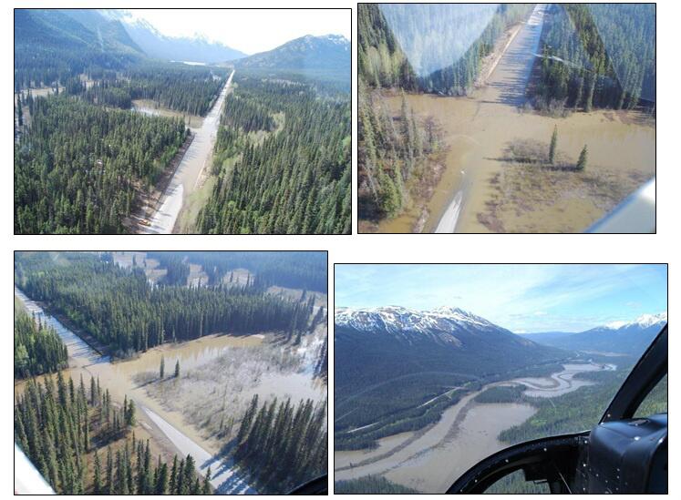
sue t.
Pictures from our many RV Adventures to Yukon & Alaska from Vancouver Island. Now we live in Yukon!
Pictures from our many RV Adventures to Yukon & Alaska from Vancouver Island. Now we live in Yukon!
Options
- Mark as New
- Bookmark
- Subscribe
- Mute
- Subscribe to RSS Feed
- Permalink
- Report Inappropriate Content
May-31-2013 01:08 PM
The DW is from Stewart, and when she was a kid the only way in or out was by boat or plane there wasn’t a road connecting Stewart to Mazeaden Jct. Later in the 60’s a logging road was built that could be used to access the outside world as my DW called it, which you can still see when driving out from Stewart high up on the mountain across from Bear Glacier. The reason the road was way up there was the Bear glacier was across the valley and that high up the north side of the valley.
Soup
Soup
2018 Northern Lite 8-11 EX Dry Bath
2017 Sierra SLE, 3500 HD / 4x4 / Duramax with a 6 speed Allison Trans
Torklift Super Hitch 20K, 48" Super Truss, front and rear frame mounted tie downs
Fast Gun Long Range SS Turnbuckles, Fast Gun locks
2017 Sierra SLE, 3500 HD / 4x4 / Duramax with a 6 speed Allison Trans
Torklift Super Hitch 20K, 48" Super Truss, front and rear frame mounted tie downs
Fast Gun Long Range SS Turnbuckles, Fast Gun locks
Options
- Mark as New
- Bookmark
- Subscribe
- Mute
- Subscribe to RSS Feed
- Permalink
- Report Inappropriate Content
May-31-2013 12:50 PM
I see that the next update for Highway 37 is 24 hours away..Saturday at 10am. I am sure that if there is a change, it'll get posted x2 quickly.
Gary Haupt
Gary Haupt
Options
- Mark as New
- Bookmark
- Subscribe
- Mute
- Subscribe to RSS Feed
- Permalink
- Report Inappropriate Content
May-31-2013 12:34 PM
Back in the mid 70s we got stuck between washouts on the Cassiar. Northing to do but wait and make a social event out of it. There were probably a dozen or more cars, trucks and RVs in our little group. Those of us in the RVs had plenty of food and drink to share with everyone. The truckers had their sleepers for night time, some people set up tents but all in all it was a fun adventure. As I remember we were there for about 3 nights.
The Dease Lake area can have some real yucky weather, especially for flying small aircraft. Often times the coastal weather will drift over to the Cassiar and fog with rain will prevail for days. When flying I would move over to the east a ways and follow the old railroad bed north. This was a railroad that never got finished. I believe it was originally headed for the Cassiar mining area but due to a change in the National government of Canada, the building was halted. Most all the dirt work was done, some of the bridges were finished but never did a train roll over the route. But it was great for following when flying in the scud. From Dease, the flying route would go north to Atlin and then up to Whitehorse. The railroad bed put you out at Watson Lake area.
First drove the Cassiar in 1974, a couple of years after they finished connecting the different sections together. Other than the paving it doesn't look much different these days, still lots of curves, up and downs, and scenery to ooh and aah over, at every turn. Probably a better route to take south bound in the fall time. The time we got stuck for the 3 nights was a spring trip south out of Alaska.
joe b.
Stuart Florida
Formerly of Colorado and Alaska
2016 Fleetwood Flair 31 B Class A w/bunks
www.picturetrail.com/jbpacooper
Alaska-Colorado and other Trips posted
"Without challenge, adventure is impossible".
Stuart Florida
Formerly of Colorado and Alaska
2016 Fleetwood Flair 31 B Class A w/bunks
www.picturetrail.com/jbpacooper
Alaska-Colorado and other Trips posted
"Without challenge, adventure is impossible".
Options
- Mark as New
- Bookmark
- Subscribe
- Mute
- Subscribe to RSS Feed
- Permalink
- Report Inappropriate Content
May-31-2013 09:30 AM
Thanks Sue ! your information is priceless !!
Options
- Mark as New
- Bookmark
- Subscribe
- Mute
- Subscribe to RSS Feed
- Permalink
- Report Inappropriate Content
May-31-2013 08:44 AM
Last year, in early June both the Alaska Highway and Cassiar were closed due to flooding and washouts. By July floodwatch is usually over.
The washout on the Alaska Highway was near Rancheria; it was a four-day closure. At the same time the Cassiar and Campbell Highway were closed due to flooding so NO traffic was moving south or north, including the trucks that deliver fuel and groceries to the north!
In 2011, Hwy 97 had numerous slides due to rain between Prince George and Dawson Creek. The highway was closed for an extended period. Folks had to detour into Alberta or take the Cassiar northward.
In July & August, it transitions to forest fire season. The Cassiar has closed several times in past years due to forest fires along the north end of the highway.
Keep your eyes on the road reports and keep your fingers crossed.
Also keep your RV's pantry stocked with basics just in case you experience a delay.
sue t.
Pictures from our many RV Adventures to Yukon & Alaska from Vancouver Island. Now we live in Yukon!
Pictures from our many RV Adventures to Yukon & Alaska from Vancouver Island. Now we live in Yukon!
Options
- Mark as New
- Bookmark
- Subscribe
- Mute
- Subscribe to RSS Feed
- Permalink
- Report Inappropriate Content
May-31-2013 08:22 AM
Thanks for the warning, Johnny and Sue! Now I'll be watching the DriveBC site carefully for the next couple of weeks. We won't leave Denver until June 16, but we had planned on using the Cassiar Hwy. on the way north. Maybe by nearly July 1, it will be clear sailing (bad pun). Just to be prepared though, we better check out staying on 97 after Prince George instead of using 37. That makes Prince George our "go/no-go" decision point--Dease Lake first or Dawson Creek first.
Speaking of 97, I saw today that a bridge south of Prince George is flooded and a detour is in effect at Quesnel. Just FYI.
Speaking of 97, I saw today that a bridge south of Prince George is flooded and a detour is in effect at Quesnel. Just FYI.
"Retirement is the best job I ever had!"
2015 RAM 2500 4x4 crewcab 6.7L CTD; 2016 Rockwood Signature UltraLite 5th wheel
2015 RAM 2500 4x4 crewcab 6.7L CTD; 2016 Rockwood Signature UltraLite 5th wheel
Options
- Mark as New
- Bookmark
- Subscribe
- Mute
- Subscribe to RSS Feed
- Permalink
- Report Inappropriate Content
May-31-2013 08:12 AM
Options for folks on 37 west of Houston or Burns Lake.If you are still in striking distance of those, turn and burn for PG.
If, however, you are in the Smithers and west area...
Smithers has a free RV area at the Safeway lot & wifi. There is also a campground down by the river that has services. Smithers is a nice place to spend a couple days, no doubt. Farmers Mkt os Saturday..good foods, sushi oh and a craft brewery. Not a pub..just the beer in bottles.
Hazelton..Ross Lake has some parking spots, by a lake. Old Hazelton has the Ksan campground. Turn right just thru New Hazelton...it's about 5k's. Skeena Bakery is worth the stop too...on your right in New...good, homemade stuff.
Kitwanga has a commuity cg (free)..go right, over the bridge and up the road..PAST the Cassiar CG sign, next left..past cafe and hey presto...
There is always Stewert/Hyder too..but pretty limited for stuff to do.
There are two rest areas west of Kitwnaga you can fetch up in. One 7ks west, the next about 40k's west.
There is Kleanza Cr Prov CG just east of Terrace. Also LakeElse Lake Prov CG..south on 37 at Terrace 4 way.
Terrace itself has Ferry Island...services. There is also Wal-Mart and CDN Tire for a parkig lot. Wal-Mart is 'signed' but never enforced. Plus..a simple explanantion will take care of questions.
Rupert has a ProvCG just a bit before town. There are some nice rest areas to hide out in and so on...Rupert is not so pretty in the rain, tho.
Kitimat...you can camp in several spots..Orange Bridge...1/2 way between Terrace and Kitimat..and here IN town just about anywhere or on the river.
If you have any questions about the area, I'll do what I can to assist. If you need any RV stuff, Nor-Burd by CDN Tire, Terrace, has parts and a shop.Plus there is a moble guy, Sunset RV..Maurice, who is good, too.
Gary Haupt
Options
- Mark as New
- Bookmark
- Subscribe
- Mute
- Subscribe to RSS Feed
- Permalink
- Report Inappropriate Content
May-31-2013 07:51 AM
In Whitehorse, there is a portion of the Alaska Highway that has a similar situation. A huge 'pond' has built up on the south side of the highway between town and the turn-off to the Klondike Highway. Not so high that it is flowing over the highway though.
Telephone poles are half submerged. Crews are working on it with only one lane open so their equipment can sit on the highway. Hopefully the highway maintains its integrity with the crews' help. Wouldn't be a good spot for a washout.
Telephone poles are half submerged. Crews are working on it with only one lane open so their equipment can sit on the highway. Hopefully the highway maintains its integrity with the crews' help. Wouldn't be a good spot for a washout.
sue t.
Pictures from our many RV Adventures to Yukon & Alaska from Vancouver Island. Now we live in Yukon!
Pictures from our many RV Adventures to Yukon & Alaska from Vancouver Island. Now we live in Yukon!
Options
- Mark as New
- Bookmark
- Subscribe
- Mute
- Subscribe to RSS Feed
- Permalink
- Report Inappropriate Content
May-31-2013 07:50 AM
joe b. wrote:
Hopefully they have the problem signed back at the Kitwanga junction.
Hopefully as far back as Prince George.
Gary Haupt
Options
- Mark as New
- Bookmark
- Subscribe
- Mute
- Subscribe to RSS Feed
- Permalink
- Report Inappropriate Content
May-31-2013 07:32 AM
And it's shows rain in Dease till Monday..and even then, only no rain for two days. Man..that's a nasty choice. Coming back to Terrace/Rupert/Hazelton has it's good things, but one might just about as well head east on 16 for Prince George and swing north.
Ferry from Rupert to Skagway is on June 4th and 11th
To Ketchican 1st,4th and 8th and 9th.
Gary Haupt
Ferry from Rupert to Skagway is on June 4th and 11th
To Ketchican 1st,4th and 8th and 9th.
Gary Haupt


