Turn on suggestions
Auto-suggest helps you quickly narrow down your search results by suggesting possible matches as you type.
Showing results for
- Good Sam Community
- Groups
- Bucket List Trips
- Forum
- Top of The World Highway-Between Dawson City & Chi...
Options
- Subscribe to RSS Feed
- Mark Topic as New
- Mark Topic as Read
- Float this Topic for Current User
- Bookmark
- Subscribe
- Mute
- Printer Friendly Page
Top of The World Highway-Between Dawson City & Chicken
Options
- Mark as New
- Bookmark
- Subscribe
- Mute
- Subscribe to RSS Feed
- Permalink
- Report Inappropriate Content
Jan-08-2015 08:15 AM
We have been to Alaska before but this summer plan to travel the 'Top of the World Highway' between Dawson City & Chicken. My question is whether there is a best way to drive this road, East to West or West to East? Which direction results in meeting less traffic? Which direction results in less exposure to falling off a cliff? Any other helpful hints would be appreciated. I realize this is mostly a dirt/gravel road and one has to be cautious when the road surface is wet. Sounds like the scenery makes the trip worthwhile.
27 REPLIES 27
Options
- Mark as New
- Bookmark
- Subscribe
- Mute
- Subscribe to RSS Feed
- Permalink
- Report Inappropriate Content
Jan-12-2015 09:51 PM
The only bad part of that road is from the US border to Boundry Air strip, the rest is in better shape than most other hwy's in the north.
98 Mountain Aire 34' 210 Cummins Puller and 2001 dodge dully with all the toy's, 400 + hp pullin a 2001 32.5' Okanogan 5th wheel, new to us after 5 yrs with the 28' Travel Aire. Lots of fun.
Options
- Mark as New
- Bookmark
- Subscribe
- Mute
- Subscribe to RSS Feed
- Permalink
- Report Inappropriate Content
Jan-12-2015 07:45 PM
explorenorth wrote:
Until I see for myself that it's not still the case, I'm working on the assumption that the Taylor Highway south of Walker Fork Campground still looks like this. There's been no changes to this section in the 25 years I've been driving it.
Sorry, you are correct...here is the 13 miles of dirt road, seemed paved to me.
TOW Paved
:B
Options
- Mark as New
- Bookmark
- Subscribe
- Mute
- Subscribe to RSS Feed
- Permalink
- Report Inappropriate Content
Jan-12-2015 03:40 PM
Veebyes wrote:Fer2005 wrote:
Did anybody driving a Class A have problems with the ferry crossing. I watched some you tubes and noticed a significant dip when loading and unloading from the ferry. I'm worried about dragging the rear end.
The ferry crew is very expeienced & have the equipment for whatever vehicle. Pay attention to their directions & all will be fine.
I saw the same you tube clip and I can tell you that my 30 footer got on and off with no dipping, no scrapping and no problems whatsoever. Like we said, follow the instruction of the crew and you will have no problems. Enjoy the trip.
Options
- Mark as New
- Bookmark
- Subscribe
- Mute
- Subscribe to RSS Feed
- Permalink
- Report Inappropriate Content
Jan-12-2015 10:54 AM
"The ferry crew is very expeienced & have the equipment for whatever vehicle. Pay attention to their directions & all will be fine"
Ditto, we were 60+ feet and had no problems of any kind on the ferry.
Ditto, we were 60+ feet and had no problems of any kind on the ferry.
2004 Travel Supreme 38DS04
2009 Ranger 4X4 Towed
Ready Brake, Tire Minder
2009 Ranger 4X4 Towed
Ready Brake, Tire Minder
Options
- Mark as New
- Bookmark
- Subscribe
- Mute
- Subscribe to RSS Feed
- Permalink
- Report Inappropriate Content
Jan-12-2015 07:52 AM
Fer2005 wrote:
Did anybody driving a Class A have problems with the ferry crossing. I watched some you tubes and noticed a significant dip when loading and unloading from the ferry. I'm worried about dragging the rear end.
The ferry crew is very expeienced & have the equipment for whatever vehicle. Pay attention to their directions & all will be fine.
Boat: 32' 1996 Albin 32+2, single Cummins 315hp
40+ night per year overnighter
2007 Alpenlite 34RLR
2006 Chevy 3500 LT, CC,LB 6.6L Diesel
Ham Radio: VP9KL, IRLP node 7995
40+ night per year overnighter
2007 Alpenlite 34RLR
2006 Chevy 3500 LT, CC,LB 6.6L Diesel
Ham Radio: VP9KL, IRLP node 7995
Options
- Mark as New
- Bookmark
- Subscribe
- Mute
- Subscribe to RSS Feed
- Permalink
- Report Inappropriate Content
Jan-12-2015 07:12 AM
Did anybody driving a Class A have problems with the ferry crossing. I watched some you tubes and noticed a significant dip when loading and unloading from the ferry. I'm worried about dragging the rear end.
2009 Winnebago Journey 39Z
2012 Ford Taurus Toad
2012 Ford Taurus Toad
Options
- Mark as New
- Bookmark
- Subscribe
- Mute
- Subscribe to RSS Feed
- Permalink
- Report Inappropriate Content
Jan-11-2015 02:35 PM
Until I see for myself that it's not still the case, I'm working on the assumption that the Taylor Highway south of Walker Fork Campground still looks like this. There's been no changes to this section in the 25 years I've been driving it.

Murray
Whitehorse, Yukon
http://ExploreNorth.com/
and blogging at http://ExploreNorthBlog.com/
I live to travel, and travel to really live
Whitehorse, Yukon
http://ExploreNorth.com/
and blogging at http://ExploreNorthBlog.com/
I live to travel, and travel to really live
Options
- Mark as New
- Bookmark
- Subscribe
- Mute
- Subscribe to RSS Feed
- Permalink
- Report Inappropriate Content
Jan-11-2015 09:51 AM
rag-ftw wrote:
We went West to East in mid September a few days after the first hard freeze. The border doesn't open until 8am which means you should not have any opposing traffic early in the day.
Agreed. We left Chicken early (hoping to see wildlife) and saw very little traffic through the early/worst part of the road since the border was closed. The 13 miles of pavement was a really nice break.
Options
- Mark as New
- Bookmark
- Subscribe
- Mute
- Subscribe to RSS Feed
- Permalink
- Report Inappropriate Content
Jan-09-2015 09:13 AM
We went West to East in mid September a few days after the first hard freeze. The road was mostly frozen hard so we had no dust or mud but fabulous scenery with the changing colors. I think going in the fall is better than spring because they have all summer to work on the road. Also leave as early in the morning as possible. The border doesn't open until 8am which means you should not have any opposing traffic early in the day.
Spring or fall, east or west doesn't matter as much as just doing it!!!
Spring or fall, east or west doesn't matter as much as just doing it!!!
2004 Travel Supreme 38DS04
2009 Ranger 4X4 Towed
Ready Brake, Tire Minder
2009 Ranger 4X4 Towed
Ready Brake, Tire Minder
Options
- Mark as New
- Bookmark
- Subscribe
- Mute
- Subscribe to RSS Feed
- Permalink
- Report Inappropriate Content
Jan-09-2015 08:31 AM
We went west-to-east last June 26. We camped at the Yukon River Government Campground across the river from Dawson. That allowed us to see the hulks of paddle wheel boats downstream from the campground. We also had no line for the ferry to Dawson.
After camping a couple nights at the Bonanza Creek RV Park, we were glad not to follow the 2 big west-bound caravans that were also camped there.
After camping a couple nights at the Bonanza Creek RV Park, we were glad not to follow the 2 big west-bound caravans that were also camped there.
Options
- Mark as New
- Bookmark
- Subscribe
- Mute
- Subscribe to RSS Feed
- Permalink
- Report Inappropriate Content
Jan-09-2015 07:02 AM
The Texan wrote:
Gordon, you may have been on what is called the "sixty mile cutoff" road, that runs from the Top of the World Hwy to the Taylor Hwy. We did that one year by mistake and it runs from scenery like the one Sue posted, to a very narrow mining road. It is maintained and doable, but still basically a mining road.
Ok, well that explains it then, thank you!
2013 KZ Sportsmen Classic 200, 20 ft TT
2020 RAM 1500, 5.7 4x4, 8 speed
2020 RAM 1500, 5.7 4x4, 8 speed
Options
- Mark as New
- Bookmark
- Subscribe
- Mute
- Subscribe to RSS Feed
- Permalink
- Report Inappropriate Content
Jan-09-2015 06:59 AM
lonnie4801 wrote:
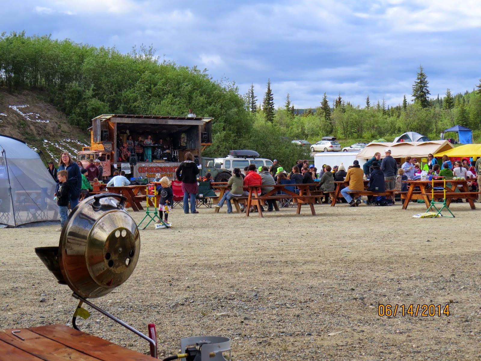
If you like "Blue Grass and Country" music, then I would recommend going east to west and attend the "ChickenStock Festival" in Chicken. The 2015 festival will be the 12th and 13th of June this year. It is a great display of wonderful local talent.
If not interested in the music then I would recommend going west to east if leaving by early September because the colors will be much better.
If not interested in either the music or the colors, they either direction will work. We have made the trip east to west 3 times and enjoyed every trip.
Chickenstock is a hoot. Did it last year. The music standard is not as good as the bluegrass in the lower 48, but then they don't claim to be. Good crowd. Mostly Alaskan getting out for first time after winter.
Boat: 32' 1996 Albin 32+2, single Cummins 315hp
40+ night per year overnighter
2007 Alpenlite 34RLR
2006 Chevy 3500 LT, CC,LB 6.6L Diesel
Ham Radio: VP9KL, IRLP node 7995
40+ night per year overnighter
2007 Alpenlite 34RLR
2006 Chevy 3500 LT, CC,LB 6.6L Diesel
Ham Radio: VP9KL, IRLP node 7995
Options
- Mark as New
- Bookmark
- Subscribe
- Mute
- Subscribe to RSS Feed
- Permalink
- Report Inappropriate Content
Jan-09-2015 05:29 AM
Gordon, you may have been on what is called the "sixty mile cutoff" road, that runs from the Top of the World Hwy to the Taylor Hwy. We did that one year by mistake and it runs from scenery like the one Sue posted, to a very narrow mining road. It is maintained and doable, but still basically a mining road.
2005 HR Endeavor 40PRQ, '11 Silverado LT, Ex Cab 6.2L NHT 4x4, w/2017 Rzr 4-900 riding in 16+' enclosed trailer in back.
Where the wheels are stopped today
Bob & Betsy - USN Aviation Ret'd '78 & LEO Ret'd '03 & "Oath Keeper Forever"
2005 HR Endeavor 40PRQ, '11 Silverado LT, Ex Cab 6.2L NHT 4x4, w/2017 Rzr 4-900 riding in 16+' enclosed trailer in back.
Where the wheels are stopped today
Options
- Mark as New
- Bookmark
- Subscribe
- Mute
- Subscribe to RSS Feed
- Permalink
- Report Inappropriate Content
Jan-09-2015 05:17 AM
Is there another road from Chicken to Dawson? There was payment from Tok to Chicken, and some old broken pavement between Dawson and the border checkpoint, but the road I drove 6 months ago between the border and Chicken was very coarse gravel, very narrow with no shoulders and steep drop offs. Lots of steep slippery grades. Maybe I was on a logging / mining road by mistake? The road looked nothing like the pictures posted here.
2013 KZ Sportsmen Classic 200, 20 ft TT
2020 RAM 1500, 5.7 4x4, 8 speed
2020 RAM 1500, 5.7 4x4, 8 speed


