Turn on suggestions
Auto-suggest helps you quickly narrow down your search results by suggesting possible matches as you type.
Showing results for
- Good Sam Community
- Everything RV
- Campground 101
- Question about Kennedy Meadows in Southern Sierra
Options
- Subscribe to RSS Feed
- Mark Topic as New
- Mark Topic as Read
- Float this Topic for Current User
- Bookmark
- Subscribe
- Mute
- Printer Friendly Page
Question about Kennedy Meadows in Southern Sierra
Options
- Mark as New
- Bookmark
- Subscribe
- Mute
- Subscribe to RSS Feed
- Permalink
- Report Inappropriate Content
May-10-2016 03:44 PM
There is still a lot of snow at the higher elevations in the Sierra, but I think it may have largely melted off in the Kennedy Meadows area. (This is the KM area near Pearsonville in the southern Sierra, not the one near Sonora Pass.) I know the road in and out is tough, but I think I can handle it, slowly and carefully, both up and down. We have never been up there, even though it is much closer to home than the northeastern part of the Sierra, where we often go.
My real question is this: although I very strongly support the idea that folks should be free to ride ATVs and motorcycles on forest roads, I don't really want to be around motorized vehicles when I am hiking and camping -- I like silence. The impression I get from various reports on that part of the Sierra is that there is a lot of off-road vehicle activity. Is it possible to find peace and quiet up in that area, or should I look elsewhere? Are different parts of that zone (maybe around Sherman Pass) quieter than other parts?
Assuming that there is not too much motorized action up there, can you recommend some good hiking trails? My research has not turned up much -- the guidebooks don't focus on that part of the Sierra at all.
Thanks in advance for your advice!
2012 Fun Finder X-139 "Boondock Style" (axle-flipped and extra insulation)
2013 Toyota Tacoma Off-Road (semi-beefy tires and components)
Our trips -- pix and text
About our trailer
"A journey of a thousand miles begins with a single list."
2013 Toyota Tacoma Off-Road (semi-beefy tires and components)
Our trips -- pix and text
About our trailer
"A journey of a thousand miles begins with a single list."
Labels:
- Labels:
-
Boondocking
-
Dry Camping
-
Public Lands
17 REPLIES 17
Options
- Mark as New
- Bookmark
- Subscribe
- Mute
- Subscribe to RSS Feed
- Permalink
- Report Inappropriate Content
May-15-2016 01:36 PM
Thanks again for the tips! Very helpful.
2012 Fun Finder X-139 "Boondock Style" (axle-flipped and extra insulation)
2013 Toyota Tacoma Off-Road (semi-beefy tires and components)
Our trips -- pix and text
About our trailer
"A journey of a thousand miles begins with a single list."
2013 Toyota Tacoma Off-Road (semi-beefy tires and components)
Our trips -- pix and text
About our trailer
"A journey of a thousand miles begins with a single list."
Options
- Mark as New
- Bookmark
- Subscribe
- Mute
- Subscribe to RSS Feed
- Permalink
- Report Inappropriate Content
May-15-2016 09:27 AM
Not sure how much you will enjoy the Kennedy Meadows area with a lot of single track (motorcycle) tracks. Not much ATV or 4x4 off highway trails up there, except a very few select forest service roads which are allowed to be ridden on. We have camped a lot at Horse Meadows Forest Service Campground (more on the west side of the range). Did not go last year because of the drought, most likely Salmon Creek was mostly dry (it was almost dry the year before). There are a few dry camping sites (free) in the area. There is some private land in the area, mostly cattle ranching.
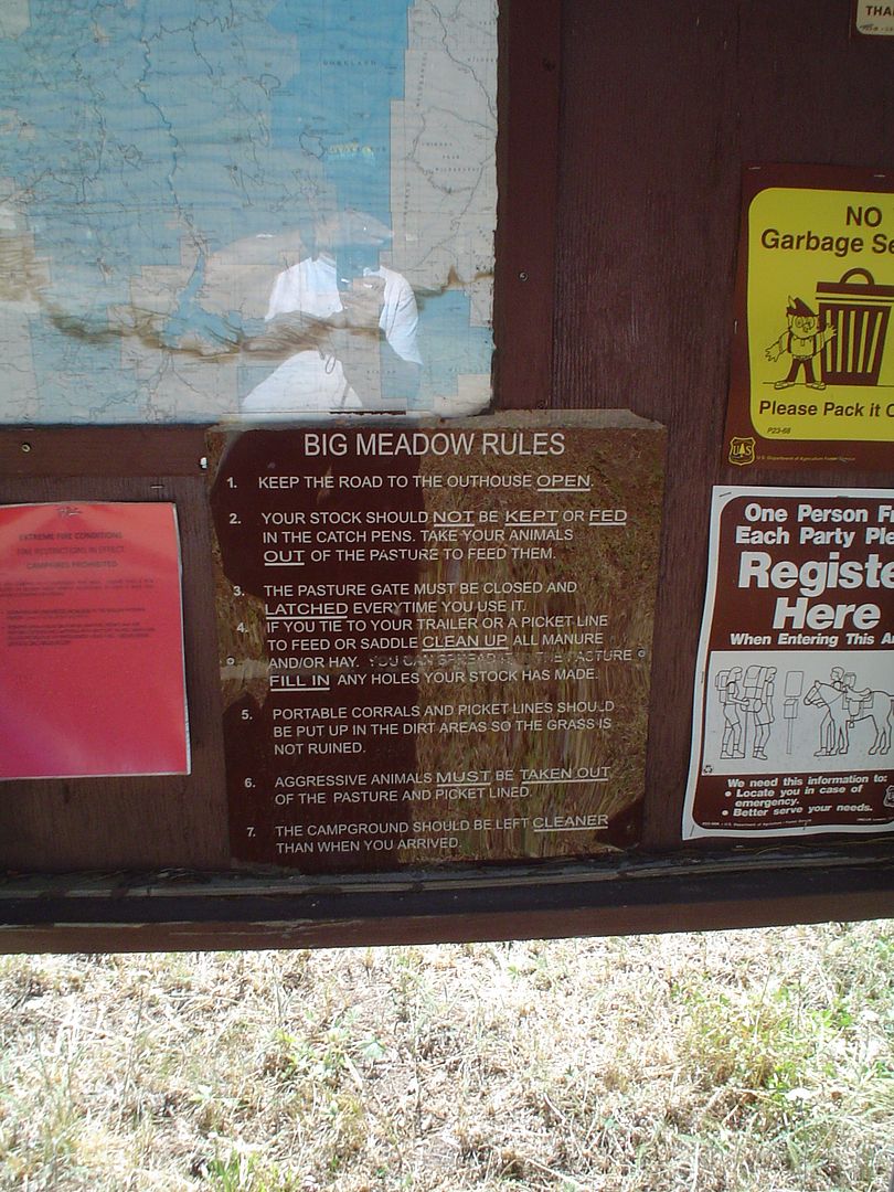
We've done some hiking in the area. Big Meadows to Salmon Creek falls and back. The Salmon Creek trail goes a lot further east into the mountains than we have explored. On the East side of Big Meadow there are few trails that take you east and loop back. In this area of the Sequoias (away from Kennedy Meadows) the motorcycle riding is restricted to one main trail that goes near Big Meadows, but for the most part you will not see them.
You will hear the occasional truck/camper/rancher on Cherry Hill Road (FR 22s12).
We get there by taking 14 North to Walker Pass West to Lake Isabella, North to Kernville (fuel up here). North along the Kern River (this can become an absolute zoo during holidays, just drive through and watch for pedestrians, slow drivers, and people who cannot park completely off the road). Just past Brush Creek, hard right turn onto Sherman Pass Road (start a slow ascent on a windy two lane paved road for about 6 miles). Turn right onto Cherry Hill Rd (FR 22S12). This road is mostly 1 to 1.5 lanes wide, windy, slow, blind corners, is mostly paved for about 5 or 6 miles, then becomes dirt, washboard, bouncy, windy. The locals (ranchers) will drive it pretty fast sometimes, I think I average about 15mph on this road. We go about 9 or 10 miles to Horse Meadow Campground (last time we were there $17/night), they might have running water, pit toilets, no trash pickup. There are about 40 sites, but typically you might see 4 in use. Cherry Hill road continues South along the range for another 20 miles or so, lots of dispersed camping areas.
Leaving this area, or leaving Kennedy Meadows - make sure you are prepared for a long steep descent and can stop your vehicle.
Options
- Mark as New
- Bookmark
- Subscribe
- Mute
- Subscribe to RSS Feed
- Permalink
- Report Inappropriate Content
May-12-2016 02:57 PM
Probably alluding to Sherman Pass and Cherry Hill Rd. coming over from the Mtn 99/ Johnsondale side. Kennedy Meadows CG and the dispersed area along the south fork of the Kern River shouldn't be too over run with ohv's and motorcycles yet til school is out.
Options
- Mark as New
- Bookmark
- Subscribe
- Mute
- Subscribe to RSS Feed
- Permalink
- Report Inappropriate Content
May-12-2016 08:15 AM
I talked to the ranger yesterday afternoon -- they say that although the road to Kennedy is open from Pearsonville, a lot of the other roads up there are still blocked by snow and closed to all traffic. So we will see -- still considering various options . . . .
2012 Fun Finder X-139 "Boondock Style" (axle-flipped and extra insulation)
2013 Toyota Tacoma Off-Road (semi-beefy tires and components)
Our trips -- pix and text
About our trailer
"A journey of a thousand miles begins with a single list."
2013 Toyota Tacoma Off-Road (semi-beefy tires and components)
Our trips -- pix and text
About our trailer
"A journey of a thousand miles begins with a single list."
Options
- Mark as New
- Bookmark
- Subscribe
- Mute
- Subscribe to RSS Feed
- Permalink
- Report Inappropriate Content
May-11-2016 06:00 PM
Dan , Google Rock House Basin and Long Meadow CG. Not too popular as it's in and out route. Remote, quiet, a windmill and an outhouse with a small CG off of Chimney Peak Rd coming in off the Hwy 178 by Canebrake on the west side of Walker Pass. Dirt from 178 up hill with a few switchbacks, there is another CG up from the fork going to Rock House Basin, just before you top out at Chimney Peak, name escapes me right now. BLM "should" have the Canebrake Rd graded by now as they have a station at Chimney Peak and usually access it from that side. Have a cold one at Grumpy Bears between Chimney and Kennedy Mdws. 9 Mile Canyon is the paved way up off 395, but if you take your time you'll be okay. Coming down is the exciting drive....:)
Options
- Mark as New
- Bookmark
- Subscribe
- Mute
- Subscribe to RSS Feed
- Permalink
- Report Inappropriate Content
May-11-2016 12:59 PM
No kidding about the MTB's. Even 20 years ago, I was nearly run down by a mountain biker on the Freeman Creek Trail. There was also much OHV activity then, and trails were very dusty.
This area was where I set my Personal Best of remoteness: 48 hours without seeing or hearing another person or vehicle. It is probably more populated these days.
Some fairly current resources for the area:
USFS Sequoia NF list of hikes:
https://fs.usda.gov/Internet/FSE_DOCUMENTS/fsbdev3_058588.pdf
A SummitPost overview page for the Southern Sierra:
http://www.summitpost.org/southern-sierra/172317#chapter_10
2006 Tiger CX 4x4, 8.1 L gas V-8, Allison 6-speed
Options
- Mark as New
- Bookmark
- Subscribe
- Mute
- Subscribe to RSS Feed
- Permalink
- Report Inappropriate Content
May-11-2016 11:51 AM
Prof, maybe it's time to dust off your mountain bikes? You're in MTB country now.
Otherwise look at bald mt, Sherman Pk.
If you're high speed/high miles maybe drive into kennedy meadows and pick up one of the many trails (ibcluding Pac Crest) going itno the Domelands.
Otherwise look at bald mt, Sherman Pk.
If you're high speed/high miles maybe drive into kennedy meadows and pick up one of the many trails (ibcluding Pac Crest) going itno the Domelands.
Options
- Mark as New
- Bookmark
- Subscribe
- Mute
- Subscribe to RSS Feed
- Permalink
- Report Inappropriate Content
May-11-2016 09:11 AM
Sequoia NF Kern Plateau website
This site has a list of hiking trails and established campgrounds.
Sequoia NF High Country info:
link
I dug out my old trip logs last night. 1997: did a bunch of hikes. 2007: mostly driving, unable to hike due to knee issues. All of my camping was in dispersed sites. More info later today if you wish (hike names, camp locations).
The Jenkins books are confusing to use, but complete. Unfortunately, they are from 1992. I will scout around later today for more info on hikes for you.
2006 Tiger CX 4x4, 8.1 L gas V-8, Allison 6-speed
Options
- Mark as New
- Bookmark
- Subscribe
- Mute
- Subscribe to RSS Feed
- Permalink
- Report Inappropriate Content
May-11-2016 08:27 AM
I am getting more interested, thanks to those tips and the photos. Now if I can find some good hiking trails . . . .
2012 Fun Finder X-139 "Boondock Style" (axle-flipped and extra insulation)
2013 Toyota Tacoma Off-Road (semi-beefy tires and components)
Our trips -- pix and text
About our trailer
"A journey of a thousand miles begins with a single list."
2013 Toyota Tacoma Off-Road (semi-beefy tires and components)
Our trips -- pix and text
About our trailer
"A journey of a thousand miles begins with a single list."
Options
- Mark as New
- Bookmark
- Subscribe
- Mute
- Subscribe to RSS Feed
- Permalink
- Report Inappropriate Content
May-10-2016 09:23 PM
I have been there several times, but not since the big fires 10-15 years ago. The first time, the only tracks on the trails in June were me and the bears. One trail I wanted to hike was having a cattle drive that day, lots of trucks and mess. Wonderful area, fun to explore. The guide books, two volumes of Exploring the Southern Sierra, by Ruby Jenkins, are out of date, but still available on Amazon. Check the USFS website for updates on dispersed camping.
A nearby area to explore if the KP does not work out for you is the Western Divide.
I can't wait to see your trip report.
A nearby area to explore if the KP does not work out for you is the Western Divide.
I can't wait to see your trip report.
2006 Tiger CX 4x4, 8.1 L gas V-8, Allison 6-speed
Options
- Mark as New
- Bookmark
- Subscribe
- Mute
- Subscribe to RSS Feed
- Permalink
- Report Inappropriate Content
May-10-2016 08:56 PM
Some of the pics from the area I was looking at telling you about.....
Options
- Mark as New
- Bookmark
- Subscribe
- Mute
- Subscribe to RSS Feed
- Permalink
- Report Inappropriate Content
May-10-2016 08:51 PM
http://i62.photobucket.com/albums/h84/siseley/camping%20and%20travels/horsefairandsequoia079.jpg
http://i62.photobucket.com/albums/h84/siseley/camping%20and%20travels/horsefairandsequoia076.jpg
http://i62.photobucket.com/albums/h84/siseley/camping%20and%20travels/horsefairandsequoia052.jpg
http://i62.photobucket.com/albums/h84/siseley/camping%20and%20travels/horsefairandsequoia044.jpg
http://i62.photobucket.com/albums/h84/siseley/camping%20and%20travels/horsefairandsequoia076.jpg
http://i62.photobucket.com/albums/h84/siseley/camping%20and%20travels/horsefairandsequoia052.jpg
http://i62.photobucket.com/albums/h84/siseley/camping%20and%20travels/horsefairandsequoia044.jpg
Options
- Mark as New
- Bookmark
- Subscribe
- Mute
- Subscribe to RSS Feed
- Permalink
- Report Inappropriate Content
May-10-2016 08:45 PM
Yes!
Sometimes lots of white stuff until mid-late June!
But the trails up from Big Meadow are very easy to see, and are by now almost snow free.
Sometimes lots of white stuff until mid-late June!
But the trails up from Big Meadow are very easy to see, and are by now almost snow free.
Options
- Mark as New
- Bookmark
- Subscribe
- Mute
- Subscribe to RSS Feed
- Permalink
- Report Inappropriate Content
May-10-2016 08:37 PM
Steve, thanks for the tip! If we go, we will bring our snowshoes for sure -- the snow at 11,000 won't melt till late June, I'd guess.
2012 Fun Finder X-139 "Boondock Style" (axle-flipped and extra insulation)
2013 Toyota Tacoma Off-Road (semi-beefy tires and components)
Our trips -- pix and text
About our trailer
"A journey of a thousand miles begins with a single list."
2013 Toyota Tacoma Off-Road (semi-beefy tires and components)
Our trips -- pix and text
About our trailer
"A journey of a thousand miles begins with a single list."


